Madhyamaheshwar or Madmaheswar is a part of famous “Panch kedar”. The middle (madhya) or belly part or navel (nabhi) of the bull, considered a divine form of Shiva, which is worshipped at this temple, believed to be built by the Pandavas.
Madhyamaheshwar is located at Mansoona village of Rudraprayag district in Garhwal Himalaya and can be reached by trekking from Ransi village. Ransi is the last motor-able point. Trekkers are requested to take porters from here.

The Legend:
The legend of Madhyamaheswar is an integral part of the legend of Panch Kedar, which is a captivating narration of the efforts of Pandavas to atone for the sins of their fratricide (gotra- hatya) act of killing their cousins, the Kauravas, and Brahmanahatya (killing of Brahmins – the priest class), during the epic Mahabharata war. On advice from sages and their trusted benefactor god Krishna they sought Lord Shiva to pardon them and bless them to attain salvation.
Since Shiva was annoyed with them for their conduct during the Kurukshetra war, he tried to avoid them by assuming the animal form of a bull or Nandi and hid himself in the Himalayan Garhwal region. But the determined Pandavas, after sighting Shiva in the form of the bull grazing in the hills of Guptakashi, tried to forcibly hold the bull by its tail and hind legs. But the bull disappeared into the ground to reappear later in his original self of Lord Shiva at five places; in the form of a hump at Kedarnath, in the shape of bahu (arms) at Tungnath, with his face at Rudranath, his nabhi (navel) and stomach at Madhyamaheswar and his hair (locks) called jata at Kalpeshwar.
The team and planning:
I visited Madhyamaheshwar in October, 2015. This time our team consisted of my senior friend Mr. Avra Ghosh and myself. Avra is a school teacher, a singer and a very good photographer. He is one of the most creative person ever I have seen. We planned to visit Madhyamaheshwar and Deoria Taal in this trip.

Since we were only two like-minded people in the team, we did not book any accommodation in this trip, instead we talked to our friend Mr Lakhpat Singh Negi of Sari village in Garhwal. Lakhpat is the owner of a hotel in Sari village and also arranges everything in this part of Himalaya.
Reaching to basecamp (Ukhimath):
We started from Kolkata on 2nd October and reached Haridwar on 3rd October. Ensuring our lodging in a hotel at Haridwar we went out for a photowalk. It was a successful evening in respect to photography.
Next morning we started for Ukhimath. First we went to Rishikesh Taxi Stand from Haridwar by an auto rickshaw and from there we took a shared car and drove to Rudraprayag. From Rudraprayag we took another shared car to Ukhimath where our friend Lakhpat was waiting for me with his car. His car took us to a budget hotel in Ukhimath.

Next morning we tried to take some photographs of sunrise. At around 8pm Lakhpat came with his car and drove us to Ransi village where our porter Mr Birbal Panwar (arranged by Lakhpat) was waiting for us.
The trek:
After breakfast we started our trek from Ransi at around 11am.
Day 1: Ransi (2100 meter) to Bantoli (1800 meter) [8km]
It was completely the trekkes’ choice whether they will stay at Bantoli or Gondar. I suggest to stay at Bantoli. The distance between Ransi to Gondar is 6km and Ransi to Bantoli is 8 km. So it will be better to stay at Bantoli as it will help next day.
Ransi is located at the bank of Madhyamaheshwar Ganga. From Ransi the trail gradually descends into forests along the river. Small streams of water is visible in the trail. After a sharp turn, a small temple is visible. From this turn if the weather is clear, Chaukhamba is visible.

After walking around 2 km we reached at Agtolidhaar. Agtolidhaar is not a village but there is a shop where a middle age lady runs a small stall of tea and rhododendron juice. We drank rhododendron juice and started trekking.
The trail gradually descends into forests. The layers of green hills are pleasure to eyes. After walking 1km, we found a waterfalls.
The trail gradually descends from here and after walking about 3 km we reached at Gaundhar. Gaundhar is a nice village where we had tea in a small tea shop. As I mentioned earlier, we did not stay here and started towards Bantoli. After trekking about 1km we reached at the bridge that spans Markanda Ganga. On the east side of the bridge, the confluence of Markanda Ganga and Madhyamaheshwar Ganga is visible.
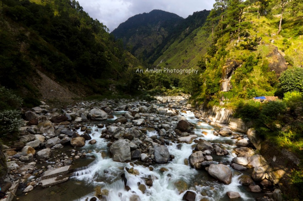
This is the lowest point of the trek. Scenic beauty of this place cannot be expressed in literature. We spent more than half an hour here.
From here the rail goes up towards Bantoli which is just 1km away. Bantoli is a beautiful village. We stayed in a local villager’s home.
Day 2: Bantoli (1800 meter) to Madhyamaheshwar (3300 meter) [9km]
We started trekking on the trail into dense forest. The path rises steadily past Khatara (2km) to Nanu (2km). Nanu is a small village. A consistent tug at the calf muscle needs rest. So it is better to stop here for 30minutes.

From Nanu the forest becomes denser and the trail is steep. It was a well-graded path with changing views of grassy slopes, emerald streams.

After walking 2km we got very tired and somehow managed to reach Maykhamba. There is a small trekkers’ hut in Maykhamba but we did not stay. Instead, we had lunch at Maykhamba as it was almost 2pm.

From Maykhamba the trail sharply rises into forest and after travelling a distance about 3km, suddenly forest gets ended and a meadow appears. Madhyamaheshwar comes. A north Indian type of temple comes in front of eyes. The holy sound of the bell makes the soul sacred.
Archietecture:
The temple in the north Indian style of architecture, is situated in a lush meadow, just below a high ridge. The temple here contains a superb Har-Gouri statue. There are two other smaller shrines, one for Shiva’s consort Parvati and the other dedicated to the Ardhanarishwara, a half-Shiva half-Parvati image.

Bhima, the second Pandava brother is believed to have built this temple and worshipped Shiva here. To the right of the main temple there is a small temple where the image of Saraswati.
Day 3: Madhyamaheshwar (3300 meter) to Buddha Madhyamaheshwar (3300 meter) [3km] and back
Next morning we started for Buddha Madhyamaheshwar before sunrise. It took near about one and half hour to gain the top of the ridge lying to the north west of the temple.

Unfortunately we were unable to see sunrise but after walking around one hour we were able to see Mt. Chaukhamba.

We reached at Buddha Madmaheshwar. This place is a beautiful meadow with three small ponds, small temple and an awesome view of Mt. Chaukhamba and Mt. Mandani. Reflection of Mt. Chaukhamba and Mt. Mandani is the main attraction of this place.

All the four peaks of Mt. Chaukhamba and twin peaks of Mandani are visible from here.

My vocabulary is insufficient to express the beauty of this place. We spent more than 2-3 hours for photography.

I would suggest the readers of this post to stay here instead of staying at Madhyamaheshwar. For that the trekkers need to carry tents, mattresses and sleeping bags. Please ask your travel agent to arrange them.
Day 4: Madhyamaheshwar (3300 meter) to Gaundhar (1900 meter) [11km]
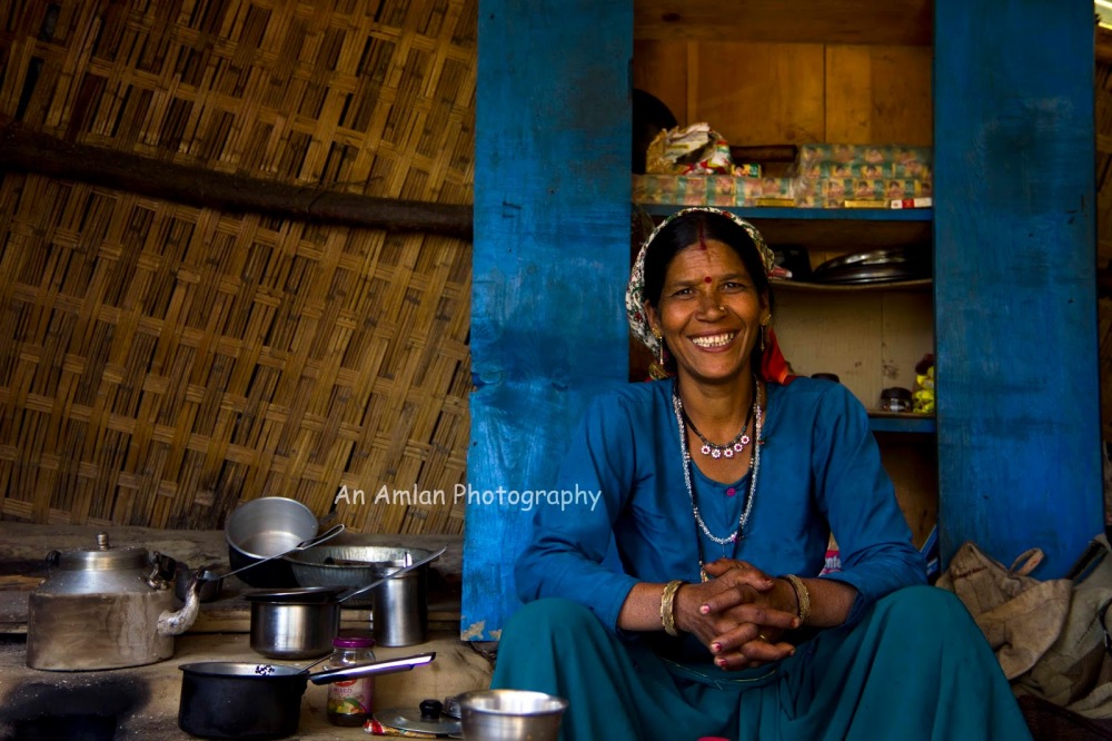
We trekked back by the same trail to Gaundhar. Since Gaundhar is closer to Ransi we decided to stay there. In the evening, we were busy in chit-chatting with local villagers to know their social structure life style etc. It was a nice experience for us to know them.

Day 5: Gaundhar (1900 meter) to Ransi (2100 meter) [8km]
We trekked back by the same trail to Ransi. We stopped at Agtolidhar for rhododendron juice as said above. At aroung 11.30 am, we reached at Ransi where our friend Lakhpat Singh Negi was waiting for us with his car. We started our journey for Sari Village from where we went to Deoria Taal.
Tips to the readers:
1. Try to start trek every day as early as possible as the trail passes through forest.
2. Take efficient and responsible porters and behave properly with them. Our porter Birbal Panwar and his brother are very responsible and efficient. Birbal’s contact number is – 09917147497
3. Try to stay at Buddha Madhyamaheshwar (instead of Madhyamaheshwar) by pitching tent. Be well equipped with tents, mattresses, sleeping bags and food.
4. Arachnophobiacs please think twice before this trek, even I was scared to see big spiders.
5. Please respect local villagers and their customs.
Reference:
1. Paye Paye Pahare by Mr. Pradip Dey Sarkar,Boiwala Publications, 2002
2. Across Peaks & Passes in Garhwal Himalaya by Mr. Harish Kapadia. Indus Publishing
3. Outlook Traveller Gateways – Uttarakhand

good write-up. it will help the new trekkers who are interested to go to madmaheswar. well done.
LikeLike
This is interesting and provides great information for trekkers. I also really like your photos.
LikeLike
I really love the mythology behind the place and the stories of Lord Shiva! Love the photos as well. Thanks for sharing!
LikeLike
Thanks for sharing your awesome experience in words and pictures. Can you please share how much porter charged for the trek?
LikeLike
gr8….We are planning to visit Madmaheshwar in end of July 2018….Can accommodation at Madmaheshwar booked in advance….pplese help
LikeLike
gr8….We are planning to visit Madmaheshwar in end of July 2018….Can accommodation at Madmaheshwar booked in ….advance….pplese help…. Shelesh Gupta 9888506810 Gupta.shelesh@gmail.com
LikeLike
Your house is valueble for me. Thanks!…
LikeLike
[…] visited to Deoria Taal on October 2015 right after our Madhya Maheshwar trek. After treeking down to Ransi (last motor able point of Madhyamaheswar trek) we found our friend […]
LikeLike
Good composition Amlan! The photos perfectly speak of the awesome experience that you had!
Happy blogging!
LikeLike